White Alice
Wikipedia - White Alice Communications System
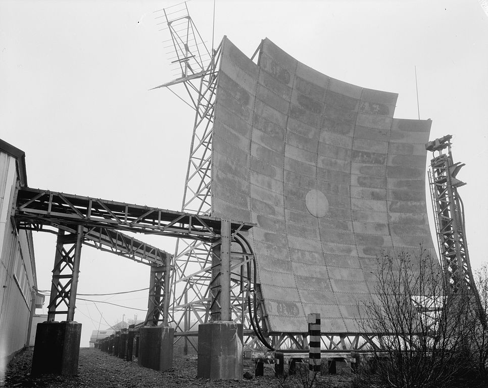
The White Alice Communications System (WACS, "White Alice" colloq.) was a United States Air Force telecommunication network with 80 radio stations[1] constructed in Alaska during the Cold War. It used tropospheric scatter for over-the-horizon links and microwave relay for shorter line-of-sight links. Sites were characterized by large parabolic, tropospheric scatter antennas as well as smaller microwave dishes for point to point links.
The system connected remote Air Force sites in Alaska, such as Aircraft Control and Warning (AC&W), Distant Early Warning Line (DEW Line) and Ballistic Missile Early Warning System (BMEWS), to command and control facilities and in some cases it was used for civilian phone calls. The system was advanced for its time, but became obsolete within 20 years following the advent of satellite communications.
Background
White Alice was conceived in the 1950s when Alaska had only basic telephone communication systems. For example, prior to White Alice only one phone call at a time could be placed from Nome to Fairbanks. Communication improved after White Alice was installed, but even in the mid 1960s an Anchorage resident had to go to one location downtown to place a call to the lower 48.
The Air Force built the White Alice Communications System with numerous support facilities around the state to provide reliable communications to far-flung, isolated, and often rugged locales. Construction began in 1955 and the system was dedicated in 1958. In the end, 71[2] systems were installed throughout Alaska. White Alice was designed by Western Electric, and civilian contractors maintained it. In 1976, the WACS was leased to RCA Alascom. By the end of the 1970s, most of the system was deactivated.
In the 1950s the Air Force used two word code names and White Alice was the code name selected for the project. It is fairly certain that White was used to indicate the snowy Arctic sites that the system would serve. However, it is unclear where the term Alice originated. Some sources suggest that Alice is an acronym for ALaska Integrated Communications Enterprise. Other sources suggest that the system would have been named Alice White had there not been an actress with that name at the time. Thus it was reversed to White Alice. It is also possible that the code name White Alice was selected for no particular reason.
Construction
The United States Army Corps of Engineers (USACE), Alaska district surveyed and selected each one of the original sites. It also constructed 11 of the original 31 sites. The selection process required that survey teams test the propagation path by setting up communication towers at each remote site during winter months. Some of the sites were easily accessible, but most of the sites were far from civilization on remote mountain peaks. 14 tons of equipment were taken by dogsled or helicopter to survey the sites.
Construction was extremely expensive, with initial estimates around $30 million, but the first phase cost over $110 million. Project Stretchout drove costs over $300 million. Part of this expense was due to Western Electric's underestimate of maintenance requirements. They initially estimated that a single site would require six people and one 25 kW generator. However, each site required 20 people and 120 to 180 kW of electrical power to operate. In remote areas, an airfield was constructed to deliver supplies to the sites. Since electricity was not available at the sites, diesel generators and fuel tanks had to be placed, and quarters for the technicians were also required. Mountain top sites had an upper camp with the electronic equipment and a lower camp with support facilities. These were sometimes connected by a tram system. In addition to the support equipment, a typical White Alice repeater site consisted of four tropospheric dishes, grouped in pairs of two facing opposite directions to receive and transmit information from adjacent sites.
Operation
The tropospheric scatter system operated around 900 MHz, and utilized both space diversity and frequency diversity, multiplexing a maximum of 132 simultaneous voice channels. The tropospheric hops used pairs of 60 ft (18 m) or 120 ft (37 m) parabolic, billboard like reflectors pointed at a low angle into the horizon. The radio waves were scattered by the tropopause, returning to Earth beyond the horizon, allowing communication between stations hundreds of miles apart. Having two antennas allowed for space diversity, meaning that if tropospheric conditions degrade on one path the second path might still be clear and communications would not be disrupted. For frequency diversity, each antenna transmitted two separate frequencies. Using both frequency and space diversity was called quad diversity. System power output for most shots was 10 kW and used 60 ft (18 m) antennas. Longer shots used 120 ft (37 m) antennas with 50 kW and shorter shots used 1 kW and 30 ft (9 m), round parabolic dishes.
Decommissioning and aftermath
After 1970, WACS was transferred from Air Force control to RCA Alascom and served civilian use until the late 1970s, when it was superseded by satellite communication earth stations. The last tropospheric link, from Boswell Bay to Neklasson Lake, was used until January 1985 to connect Middleton Island to the network. Vandalism, unsafe conditions and environmental concerns caused the Department of Defense (DOD) to remove physical structures at the sites between the late 1980s to the early 2000s. Several former White Alice sites and collocated facilities became contaminated sites managed by Alaska's Department of Environmental Conservation - Contaminated Sites Program and DOD Cleanup programs sites because of PCB usage and fuel leakage from storage tanks. It is likely the cost to clean up some of the sites will far exceed the cost of construction.
Tropospheric scatter
Wikipedia - Tropospheric scatter
Tropospheric scatter (also known as troposcatter) is a method of communicating with microwave radio signals over considerable distances – often up to 300 kilometres (190 mi), and further depending on terrain and climate factors. This method of propagation uses the tropospheric scatter phenomenon, where radio waves at UHF and SHF frequencies are randomly scattered as they pass through the upper layers of the troposphere. Radio signals are transmitted in a narrow beam aimed just above the horizon in the direction of the receiver station. As the signals pass through the troposphere, some of the energy is scattered back toward the Earth, allowing the receiver station to pick up the signal.
Normally, signals in the microwave frequency range travel in straight lines, and so are limited to line of sight applications, in which the receiver can be 'seen' by the transmitter. Communication distances are limited by the visual horizon to around 30–40 miles (48–64 km). Troposcatter allows microwave communication beyond the horizon. It was developed in the 1950s and used for military communications until communications satellites largely replaced it in the 1970s.
Because the troposphere is turbulent and has a high proportion of moisture the tropospheric scatter radio signals are refracted and consequently only a tiny proportion of the radio energy is collected by the receiving antennas. Frequencies of transmission around 2 GHz are best suited for tropospheric scatter systems as at this frequency the wavelength of the signal interacts well with the moist, turbulent areas of the troposphere, improving signal to noise ratios.
Overview
Historically, high gain dish or billboard antennas were required for tropospheric scatter systems as the propagation losses are very high; only about one trillionth (1 x 10⁻¹²) of the transmit power is available at the receiver. Paths were established at distances over 1,000 km. They required antennas ranging from 9 meters to 36 meters and amplifiers ranging from 1 kW to 50 kW. These were analogue systems which were capable of transmitting a few voice channels.
Troposcatter systems have evolved over the years. With communication satellites used for long-distance communication links, current troposcatter systems are employed over shorter distances than previous systems, use smaller antennas and amplifiers, and have much higher bandwidth capabilities. Typical distances are between 50 km and 250 km, though greater distances can be achieved depending on the climate, terrain, and data rate required. Typical antenna sizes range from 1.2 meters to 12 meters while typical amplifier sizes range from 10W to 2 kW. Data rates over 20Mbit/s can be achieved with today's technology.
Tropospheric scatter is a fairly secure method of propagation as dish alignment is critical, making it extremely difficult to intercept the signals, especially if transmitted across open water, making them highly attractive to military users. Military systems have tended to be ‘thin-line’ tropo – so called because only a narrow bandwidth ‘information’ channel was carried on the tropo system; generally up to 32 analogue (4 kHz bandwidth) channels. Modern military systems are "wideband" as they operate 4-16 Mbit/s digital data channels.
Civilian troposcatter systems, such as the British Telecom (BT) North Sea oil communications network, required higher capacity ‘information’ channels than were available using HF (high frequency – 3 to 30 MHz) radio signals, before satellite technology was available. The BT systems, based at Scousburgh in the Shetland Islands, Mormond Hill in Aberdeenshire and Row Brow near Scarborough, were capable of transmitting and receiving 156 analogue (4 kHz bandwidth) channels of data and telephony to / from North Sea oil production platforms, using frequency-division multiplexing (FDMX) to combine the channels.
Because of the nature of the turbulence in the troposphere, quadruple diversity propagation paths were used to ensure 99.98% reliability of the service, equating to about 3 minutes of downtime due to propagation drop out per month. The quadruple space and polarisation diversity systems needed two separate dish antennae (spaced several metres apart) and two differently polarised feed horns – one using vertical polarisation, the other using horizontal polarisation. This ensured that at least one signal path was open at any one time. The signals from the four different paths were recombined in the receiver where a phase corrector removed the phase differences of each signal. Phase differences were caused by the different path lengths of each signal from transmitter to receiver. Once phase corrected, the four signals could be combined additively.
Tactical Troposcatter Communication systems
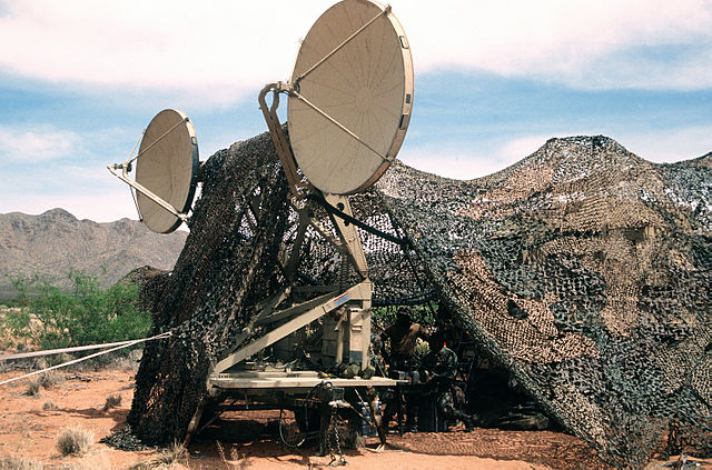
US Army AN/TRC-170 Tropospheric Scatter Microwave Radio Terminal
The U.S. Army and Air Force use tactical tropospheric scatter systems developed by Raytheon for long haul communications. The systems come in two configurations, the original "heavy tropo", and a newer "light tropo" configuration exist. The systems provide four multiplexed group channels and trunk encryption, and 16 or 32 local analog phone extensions. The U.S. Marine Corps also uses the same device, albeit an older version.
Earth Stations Bring an End to White Alice
Communications News
June, 1985
by S. Reid
The end of an era some said. Others said it was the timely death of a dinosaur. By any definition, it was the end of White Alice.
Last January 15, saw the deactivation of the only remaining White Alice link carrying public telecommunications traffic.
With their huge steel antenna clusters looking like 100-ton drive-in movie screens atop mountains from Barter Island to Shemya and Ketchikan, the White Alice sites stood in their day as unmistakable landmarks . . . as monuments to the challenge of telecommunications in Alaska.
But time has a way of turning even high tech monuments into tired relics out of step with modern technology.
Using the timely discovery that radio transmissions could be bounced off the earth's atmosphere from one site to another beyond the horizon, White Alice used massive amounts of power to blast a signal skyward--process known as tropospheric scatter. A small fraction of the signal would bounce off the troposphere and be received by another station downline.
It wasn't too efficient by today's standards, but it was the best communications technology available in the 1950s. By the latter half of that decade, thousands of construction workers, electricians, pilots, military and support personnel were in Alaska building this new link for the military. Like earlier telegraph and open-wire communications in the state, White Alice would carry civilian and military transmissions.
The name for the project, White Alice, is credited to a military study group in Washington, DC. Searching for a classified code name for the system, the group turned Alaska Integrated Communications Enterprises into "Alice," and "White" was chosen because they believed it descriptive of the area . . . and they needed two words for the name. The group was going to call it Alice White, but someone discovered a potential conflict with an actress of that name. White Alice was born.
Sites Self-Contained
White Alice sites were self-contained outposts on some of the most rugged and spectacular real estate in Alaska. Though some stations varied slightly in their configuration and radio hardware, all were staffed 24 hours a day, 365 days a year by several technicians, mechanics and housekeepers. The staff was housed in an on-site dormitory. The lifeline of most sites was an airstrip that allowed a steady stream of supplies and a way back to civilization.
White Alice remained the backbone of long-line communications for more than ten years and eventually expanded to some 60 sites including the bit tropospheric scatter transmitters and smaller microwave stations.
In 1974, under an agreement with the Air Force which owned White Alice, Alascom took over the operation and maintenance of the segment between Palmer and Ketchikan with circuits leased back to the military. Two years later Alascom assumed control of the rest of the White Alice system from the Air Force.
System Operated at Great Cost
White Alice was proving to be an expensive proposition. With all those diesel generators humming along providing power for the inefficient radio technology, it is estimated that enough electricity was generated each day to power 25,000 homes.
Satellite communications technology was emerging in Alaska as the heir apparent to the aging White Alice system. By 1975, the state legislature appropriated $5 million for construction of small satellite earth stations in 120 villages with a permanent population of 25 or more. Today Alascom has more than 160 earth stations scattered across Alaska providing a level of telecommunications never dreamed during White Alice days.
Earth Stations Take Over
Appropriately, it was the construction of a satellite earth station that put into retirement the last White Alice site at Boswell Bay on Hinchbrook Island is Prince William Sound.
Boswell Bay formed the middle link in a communications path anchored at either end by White Alice sites at Neklasson lake near Palmer and Middleton Island in the Gulf of Alaska.
With the new satellite link, and the rerouting of some marine radio and Coast Guard links, the White Alice "shot" to Neklasson Lake was no longer needed; all three remaining tropo stations at Neklasson Lake, Boswell Bay and Middleton Island could be deactivated.
With members of the television and print media present for a simple ceremony, Alascom's Tim Pettis threw a switch causing the dials on the Boswell Bay transmitter to drop rather unceremoniously dead for the first time since the 1950s.
Pettis had the distinction of idling not only those giant transmitters, but of bringing the White Alice era to an end.
COPYRIGHT 1985 Nelson Publishing
COPYRIGHT 2004 Gale Group
Wikipedia - List of White Alice Communications System sites
Original White Alice installations
These sites were part of the initial White Alice system and connected Aircraft Control and Warning (AC&W) sites with central command and control facilities. The Boswell Bay to Neklasson Lake link was both the first and last operational link in the White Alice system, serving from 1956 to 1985.
Tropospheric scatter sites
| Location
|
Operational
|
Colocated with
|
Coordinates
|
Notes
|
| Aniak, Alaska
|
1958–1979
|
N/A
|
61°34′58″N 159°35′33″W / 61.58278°N 159.59250°W / 61.58278; -159.59250
|
In flight path for Aniak Airport and antennas were painted with a red and white checkerboard pattern.
|
| Anvil Mountain, Alaska
|
1958–1978
|
N/A
|
64°33′52″N 165°22′25″W / 64.56444°N 165.37361°W / 64.56444; -165.37361
|
7½ km (4.7 mi.) north of Nome, Alaska. Last intact existing site 2016.*
|
| Bear Creek, Alaska
|
1958?-1979?
|
N/A
|
65°10′49″N 152°13′22″W / 65.18028°N 152.22278°W / 65.18028; -152.22278
|
Stand-alone site with a 5,200 sq ft (480 m2) dormitory and a 7,200 sq ft (670 m2) equipment and power building approximately six miles northeast of Tanana, Alaska
|
| Bethel, Alaska
|
1958–1979
|
AC&W site
|
60°44′36″N 161°39′58″W / 60.74333°N 161.66611°W / 60.74333; -161.66611
|
Originally six antennas. Last antenna demolished in August 2011.
|
| Big Mountain, Alaska
|
1957–1979
|
N/A
|
59°23′25″N 155°13′39″W / 59.39028°N 155.22750°W / 59.39028; -155.22750
|
Demolished 2003–2005[1]
|
| Boswell Bay, Alaska
|
1956–1985
|
N/A
|
60°25′01″N 146°09′12″W / 60.41694°N 146.15333°W / 60.41694; -146.15333
|
Demolished 1987 after extensive historical documentation.
|
| Fort Yukon, Alaska
|
1958-UKN
|
709th AC&W
|
Est.66°34′10″N 145°14′26″W / 66.56944°N 145.24056°W / 66.56944; -145.24056
|
120 ft antennas added in 1962 to Barter Island. Demolished Summer of 1999.
|
| Granite Mountain, Alaska
|
1957–1976
|
N/A
|
65°25′55″N 161°14′9″W / 65.43194°N 161.23583°W / 65.43194; -161.23583
|
Lease to Alascom 1976. 4x60 ft, 2x 30 ft (9.1 m) dishes
|
| Indian Mountain, Alaska
|
|
AC&W / Long Range RADAR
|
66°04′07″N 153°41′23″W / 66.06861°N 153.68972°W / 66.06861; -153.68972
|
Top camp was around 4,200 ft (1,300 m) and 10 miles (16 km) away from bottom camp, which contained airfield and Geodesic dome support buildings.
|
| Kalakaket Creek, Alaska
|
1957-
|
N/A
|
64°25′48″N 156°50′19″W / 64.43000°N 156.83861°W / 64.43000; -156.83861
|
Originally Tropo only, TD-2 microwave link added later.
|
| King Salmon, Alaska
|
1957–1979
|
King Salmon Air Force Base
|
58°42′19″N 156°40′08″W / 58.70528°N 156.66889°W / 58.70528; -156.66889
|
|
| Kotzebue, Alaska
|
1957–1979
|
AC&W station / FAA
|
66°50′34″N 162°36′13″W / 66.84278°N 162.60361°W / 66.84278; -162.60361
|
3 miles south of Kotzebue
|
| Cape Lisburne, Alaska
|
1957–1979
|
AC&W / Long range radar site
|
68°52′11″N 166°08′56″W / 68.86972°N 166.14889°W / 68.86972; -166.14889
|
Northern-most and only seasonal WACS, closed during winter. A $6.5 million composite building was constructed in 1970.
|
| Middleton Island, Alaska
|
1956–1985
|
AC&W station / FAA
|
59°27′36″N 146°18′21″W / 59.46000°N 146.30583°W / 59.46000; -146.30583
|
30 ft parabolic dish
|
| Cape Newenham, Alaska
|
1958–1979
|
Originally AC&W, now Long Range RADAR
|
Est.58°38′46″N 162°01′48″W / 58.64611°N 162.03000°W / 58.64611; -162.03000
|
Revamped in 1974 for $6 Million. Demolished by 1987.
|
| North River, Alaska
|
1958–1978
|
Near an AC&W site
|
63°53′00″N 160°31′50″W / 63.88333°N 160.53056°W / 63.88333; -160.53056
|
Demolished 1993–1995
|
| Northeast Cape, Alaska
|
1958-
|
AC&W
|
63°17′34″N 168°42′05″W / 63.29278°N 168.70139°W / 63.29278; -168.70139
|
A very remote site, demolished in 2003 for $10.5 million. The While Alice site was located about 1/2 mile from the USAF AC&W site.
|
| Pillar Mountain, Kodiak, Alaska
|
1957–1979
|
N/A
|
Est.57°47′19″N 152°26′12″W / 57.78861°N 152.43667°W / 57.78861; -152.43667
|
Dismantled in 1997
|
| Cape Romanzof, Alaska
|
1958–1979
|
AC&W / Minimally attended RADAR
|
61°46′53″N 165°57′04″W / 61.78139°N 165.95111°W / 61.78139; -165.95111
|
Upper camp was accessible via tramway and by road. The AC&W site was located in the crater of an extinct volcano. The While Alice site was perched on, I believe, the west rim of the crater.
|
| Sparrevohn, Alaska
|
1957–1979
|
AC&W
|
61°06′22″N 155°36′36″W / 61.10611°N 155.61000°W / 61.10611; -155.61000
|
Demolished prior to 1987. Very costly construction, dangerous runway. Long Range RADAR still at site.
|
| Tatalina, Alaska
|
1957–1979
|
AC&W site
|
62°55′41″N 156°01′30″W / 62.92806°N 156.02500°W / 62.92806; -156.02500
|
Tram and road used to reach top camp. WACS located east of RADARs in Top camp.
|
| Tin City, Alaska
|
1958–1975
|
AC&W/Long range radar
|
65°34′58″N 167°56′25″W / 65.58278°N 167.94028°W / 65.58278; -167.94028
|
Located on Cape Mountain. Tram used to reach top camp. WACS located on a 600-foot plateau 2 miles east of the peak and radar.
|
Microwave sites
Dual Tropo/Micro
Note: There were Tropo Billboards at Soldotna (co-located with the TD2) and at Fire Island, as well.
Also, There was a TD-2 site at what is now the Civil Air Patrol Wing Headquarters on Elmendorf AFB—it was called R2N.
And, there is a TD-2 site at Rabbit Creek, that was originally, and briefly, called R1S, which linked into the TD-2 site at Naptowne.
- Est. indicates location unclear from USGS topo
The BMEWS Network
The second segment of White Alice was a pair of TD-2 microwave radio links that supported the Ballistic Missile Early Warning System (BMEWS) at Clear Air Force Station. This section provided two routes from Alaska to NORAD in Colorado, for this reason it was also known as the Rearward Communications System.[3] The A Route went down the southeast coast of Alaska to a submarine cable and the B Route went east into Canada. Some of the systems were colocated with previous sites.
A Route
Aurora, Black Rapids, Boswell Bay, Cape Yakataga, Clear, Donnelly Dome, Duncan Canal, Glennallen, Harding Lake, Hoonah, McCallum, Murphy Dome, Neklasson Lake, Ocean Cape, Paxson, Pedro Dome, Sawmill, Sheep Mountain, Smuggler Cove, Tahneta Pass, Tolsona
B Route
Beaver Creek, Canyon Creek, Cathedral, Delta Junction, Gerstle River, Gold King Creek, Knob Ridge, Tok Junction
Project Stretchout sites
Project Stretchout began in 1959 and finished in the mid-1960s. It was the extension of White Alice to the Alaska Peninsula including the Aleutian DEW Line system.
Project Bluegrass sites
Extension of the White Alice system from Nikolski to Shemya near the end of the Aleutian Islands. Both shots were over 340 miles (550 km), requiring large 120 ft (37 m) antennas and 50 kW transmitters. Both sites were demolished before 1987. In addition to the Aleutian Island extension, Project Bluegrass also included a 50 kW shot from Fort Yukon to Barter Island to connect the northern DEW line to the White Alice system.